South Africans are being warned to prepare for several days of unsettled weather as a strong system moves across the country from Monday through Thursday.
The forecast points to a mix of heavy rain, strong winds, and thunderstorms affecting multiple provinces at different times.
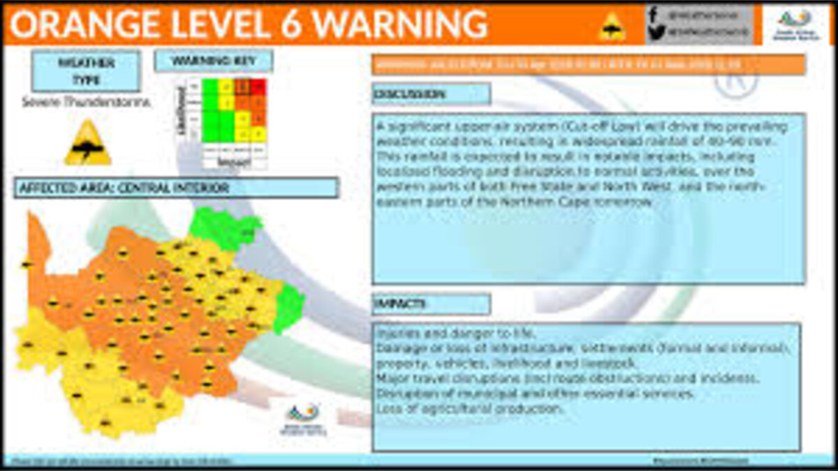
According to the South African Weather Service, the main driver of this change is a cut-off low-pressure system expected to make landfall on the western side of the country from Tuesday morning.
What Exactly Is Driving This Weather Shift?
Meteorologists describe a cut-off low as a slow-moving weather system that can linger over an area for days.
Because it doesn’t move quickly, it often brings prolonged rainfall and severe conditions.
This particular system is expected to first affect the Western Cape, Northern Cape, and Eastern Cape, before spreading inland toward the central and eastern parts of the country from Tuesday into Wednesday.
In simple terms, it’s the kind of system that doesn’t just pass through—it settles in and causes trouble.
Early Signs Already Showing Across Regions
Before the system fully arrives, scattered showers and thunderstorms are already expected over parts of the interior.
Areas like the Free State, North West, and sections of the Eastern and Western Cape could see unstable conditions from Monday.
Rainfall is expected to become heavier and more widespread along the south-western coastline as the week progresses.
By Tuesday afternoon, forecasters warn that thunderstorms could become more intense over the eastern interior, bringing a mix of heavy downpours, lightning, hail, and strong winds.
The Risk of Severe and Disruptive Weather
As the system strengthens, the risk of extreme weather increases.
Some regions, particularly the Eastern Cape and parts of the Western Cape, may experience prolonged rainfall lasting into Thursday.


Rainfall totals in some areas could reach between 100mm and 200mm within 24 hours, which significantly raises the risk of flooding.
Coastal areas are also expected to face rough sea conditions, making maritime activity dangerous and potentially disrupting ports and harbours.
Snow, Storms, and Coastal Impacts
Beyond rain and thunderstorms, colder conditions in higher-altitude areas may bring snowfall to parts of the Western Cape and Eastern Cape highlands.
This could affect livestock and lead to temporary road closures in mountain passes.
Along the coast, wind and wave activity are expected to intensify.
Waves could reach heights of over 5 to 7 metres in exposed areas, creating dangerous conditions for fishing and shipping.
Safety Concerns and Public Advisory
Authorities are urging residents to take precautions as the weather system moves through.
People are advised to avoid crossing flooded roads or fast-moving streams, secure loose outdoor objects, and limit travel where possible during severe conditions.
Flooding, falling trees, and reduced visibility are all possible hazards during this period, especially in areas already prone to drainage issues.
Impact and Consequences
The most immediate impact will likely be flooding in low-lying communities, especially in the Eastern Cape and Western Cape.
Roads, bridges, and informal settlements could be affected if rainfall totals reach the higher end of forecasts.
Strong winds may also lead to power outages and damage to weaker structures.
Transport networks—both road and coastal—could face delays or closures.
Agriculture could feel the pressure too, particularly in areas expecting hail, heavy rain, or snow, which can damage crops and livestock.
What’s Next?
Weather officials will continue to monitor the system closely as it develops.
Updates are expected as the cut-off low moves inland and conditions evolve day by day.
Residents in high-risk areas will likely receive additional alerts if rainfall intensifies or if flood warnings are upgraded.
Summary
A slow-moving cut-off low-pressure system is set to bring several days of heavy rain, strong winds, thunderstorms, and even snowfall to parts of South Africa.
The South African Weather Service has warned of possible flooding, coastal damage, and transport disruptions as the system moves across multiple provinces from Monday to Thursday.
Bulleted Takeaways
- A cut-off low-pressure system is bringing severe weather to South Africa
- The system is expected to affect Western Cape, Eastern Cape, Northern Cape, and inland regions
- Heavy rainfall could exceed 100–200mm in some areas within 24 hours
- Flooding, strong winds, hail, and lightning are major risks
- Coastal areas may face waves of 5–7 metres and dangerous sea conditions
- Snowfall is possible in higher-altitude regions of Western and Eastern Cape
- Authorities warn of road closures, power outages, and transport disruptions
- Residents are advised to avoid flooded roads and secure property outdoors
- Weather conditions are expected to persist from Monday through Thursday
