Severe weather warnings have been moving rapidly across parts of the southern United States, with emergency officials closely tracking a series of dangerous storm systems affecting multiple states.
According to updates from the National Weather Service office in Jackson, Mississippi, a tornado watch was issued covering parts of Louisiana, Mississippi, and Texas, with residents urged to stay alert and prepared for sudden changes in conditions.
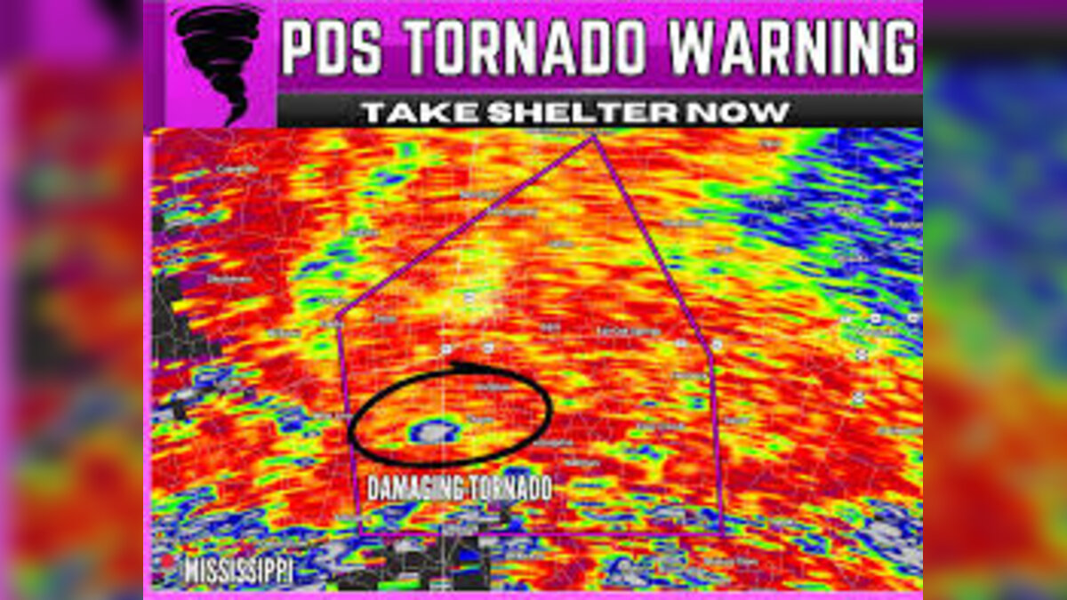
The warning system escalated quickly as storm cells strengthened, prompting repeated alerts within hours as the situation developed in real time.
Rapid Escalation as Tornado Threat Intensifies
At one point, forecasters issued an urgent warning describing a “very dangerous tornado” moving across western parts of Franklin County, Mississippi.
Officials stressed that anyone in the tornado’s projected path needed to take immediate shelter actions to protect their lives.
The language used in the alerts reflected how quickly conditions were changing on the ground.
Not long after, a similar emergency alert was issued for eastern Lincoln County, again warning residents that the tornado threat remained severe and fast-moving.
These kinds of alerts are typically reserved for the most serious tornado situations, where structural damage and life-threatening winds are highly likely.
Tornado Watch Expands Across Multiple States
As the storm system evolved, the watch zone expanded further, eventually covering parts of Alabama, Florida, Louisiana, and Mississippi.
Authorities initially warned that severe weather could continue overnight, with residents urged to remain vigilant until early morning hours.
Later updates suggested that the worst of the storm activity had moved out of some areas, with only scattered showers and isolated lightning expected to remain.
Even so, the shifting forecasts created confusion for many residents who were still experiencing intense wind, rain, and electrical activity.


Confusion and Real-Time Reactions from Residents
As warnings circulated, people across affected regions turned to social media to share updates, concerns, and real-time experiences.
Some residents described power fluctuations, loud thunder, and flickering lights, while others asked when alerts might be lifted for their specific counties.
One widely shared explanation online emphasized the difference between a “tornado warning” and a “tornado emergency,” highlighting how quickly the situation can escalate from preparedness to immediate life-threatening danger.
This kind of public clarification often spreads during severe weather events, especially when conditions change rapidly within minutes.
Early Reports of Damage Begin to Surface
As the storm system moved through parts of Mississippi, early visual reports began emerging showing the aftermath of the tornado’s path.
According to the Mississippi Weather Network, storm chasers documented significant destruction near Highway 51 and Stonebrook Trail SE.
Footage shared online showed mobile homes heavily damaged or completely destroyed, with debris scattered across residential areas.
Vehicles, trees, and nearby buildings were also reported to have sustained serious damage, particularly in more exposed areas like trailer parks.
Community Reactions and Wider Concerns
Beyond official reports, residents and online users expressed concern about the broader impact of tornadoes in the region.
Some pointed out that Mississippi and surrounding states often face heightened vulnerability due to a combination of housing conditions, infrastructure challenges, and complex terrain that can make storm tracking more difficult.
Others focused on the emotional toll, especially for communities repeatedly affected by severe weather events in recent years.
These discussions often resurface whenever major storms hit the region, highlighting long-standing concerns about preparedness and recovery resources.
Impact and Consequences
The severe weather system has already led to several important consequences:
- Emergency alerts disrupted normal nighttime activity across multiple states
- Residents were forced to seek shelter repeatedly within short timeframes
- Structural damage was reported in mobile home communities
- Power instability and weather-related anxiety increased in affected areas
- Emergency services faced pressure responding to rapidly shifting conditions
The event also underscores how quickly tornado threats can escalate in the southern U.S., especially during active storm seasons.
What’s Next?
Meteorologists expect continued monitoring of storm patterns as the system moves eastward and weakens.
Further assessments will focus on:
- Confirming the full extent of structural damage
- Identifying whether additional tornado formation is possible
- Supporting recovery efforts in heavily affected counties
- Updating residents as new weather systems develop
Local authorities are also likely to review emergency response timing and communication effectiveness once the immediate threat passes.
Summary
A powerful storm system triggered multiple tornado watches and warnings across parts of Louisiana, Mississippi, Texas, Alabama, and Florida, leading to urgent emergency alerts and reports of significant destruction in some areas.
While conditions have begun to ease in certain regions, the impact of the tornado activity is still being assessed.
Bulleted Takeaways
- Tornado watch issued across Louisiana, Mississippi, and Texas
- Emergency tornado warnings escalated to life-threatening alerts in parts of Mississippi
- Storm system later expanded to Alabama, Florida, Louisiana, and Mississippi
- National Weather Service issued repeated urgent safety updates
- Residents reported power issues, thunder, and severe weather conditions
- Early footage showed major destruction in Mississippi trailer park communities
- Mobile homes, vehicles, and trees were heavily damaged in affected areas
- Weather conditions later began to ease in some regions overnight
- Public confusion highlighted difference between tornado warnings and emergencies
- Authorities continue assessing damage and monitoring future storm risks
- South Korean judge Shin Jong-o is found dead inside Seoul High Court building after ruling in high-profile corruption appeal case
- U.S. Air Force Sends F-22 Raptors to Japan as Washington Strengthens Indo-Pacific Airpower and Warns Rivals From Kadena Air Base
- Israeli investors amass record breaking wealth as financial assets surge to historic highs across Israel in 2026
- High Court Judge Slams John McGuirk and Halts Defamation Trial Against Paddy Cosgrave in Ireland Courtroom Drama
- United Arab Emirates intercepts Iranian missiles as fresh drone attack hits oil facility in Fujairah near Strait of Hormuz
- Iran denies missile attack claims as United Arab Emirates faces deadly drone strikes across Gulf region
- Zelenskyy Pushes Ukraine Into the Gulf Security Fight as Bahrain Talks Open the Door to a Controversial Drone Deal in Manama
- Nigeria boosts export earnings in Q1 2026 as ports handle rising cargo volumes across Lagos and major seaports nationwide
- Dutch Authorities Plan to Evacuate Sick Passengers as Hantavirus Outbreak Strikes MV Hondius Cruise Ship Near Cape Verde Atlantic Ocean
- Swiss Court Hears Marc Rieben Testify as Murder Trial of Kristina Joksimovic Unfolds in Muttenz Basel Switzerland
- Barcelona Police Arrest Suspect After Fatal Knife Attack in Esplugues de Llobregat Spain Shocks Residential Community
- Otedola denies financing Dangote refinery and rejects viral claims across Nigeria business sector in Lagos Nigeria
