A growing number of climate scientists are now warning that the world may be heading toward one of the strongest El Niño events ever recorded.
Early indicators suggest that a major warming phase developing beneath the Pacific Ocean could evolve into a rare and powerful system, sometimes referred to as a “super” El Niño.
According to atmospheric monitoring data, conditions forming in 2026 are already showing unusually high intensity.
If current projections hold, this event could rival or even surpass historic El Niño patterns dating back to the 19th century.
Deep Ocean Heat Surge Raises Global Concern
At the centre of this developing situation is a massive buildup of heat beneath the Pacific surface.
Scientists say a strong Kelvin wave—a deep ocean pulse of warm water—is moving upward and is expected to eventually reach the surface.
This process acts like a trigger point, releasing stored energy into the atmosphere and reshaping global weather systems.
Once that shift begins, the effects can spread quickly, especially across tropical regions where weather systems are highly sensitive to ocean temperature changes.
Researchers tracking the system warn that this release could start reorganizing global climate patterns in the second half of 2026 and continue into 2027.
Forecast Models Point to High Chance of Extreme Event
Multiple climate models now suggest there is at least a 50% probability that this developing pattern could become a “super El Niño,” defined by sea surface temperature increases of around 2°C or more above normal.
One expert, Paul Roundy, a climatology professor at the University at Albany, noted that confidence is rising that this could become one of the most significant El Niño events in modern observational history.
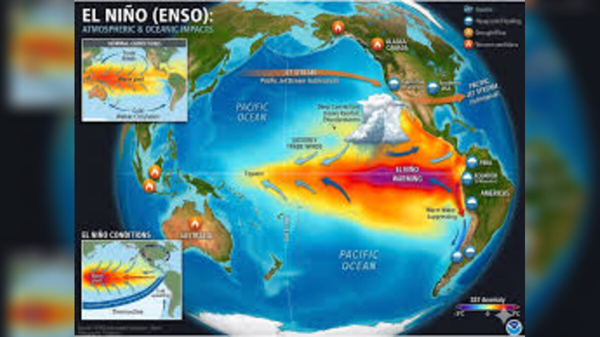
In simple terms, the stronger the El Niño, the more powerful its influence on global weather systems becomes.
What a Strong El Niño Could Mean for Global Weather
An El Niño event is not the only factor shaping global weather, but it is one of the most influential.
When it intensifies, it can shift rainfall, storm tracks, and temperature patterns across continents.
A stronger event typically leads to:


- Increased rainfall in some regions, especially parts of the Americas
- Drier-than-normal conditions in regions like Australia and parts of Asia
- Changes in hurricane activity across the Atlantic and Pacific
- Warmer winters in some areas and heavier snow in others, depending on local air conditions
Scientists warn that a “super” event would amplify all of these effects, making weather systems more unpredictable and more extreme.
Rising Risk of Floods, Droughts, and Storm Disruption
One of the biggest concerns is the potential for simultaneous extreme weather events around the world.
A stronger El Niño could shift jet streams, intensify storms in certain regions, and suppress them in others.
That means some parts of the world could face severe flooding, while others experience prolonged drought conditions.
Agricultural systems, water supply stability, and infrastructure planning could all be affected depending on the final strength of the event.
Historically, strong El Niño years have been linked to major global disruptions, including crop failures, heatwaves, and unusual storm patterns.
Why Scientists Are Watching the Pacific So Closely
Ocean temperatures in the equatorial Pacific act as a kind of “control knob” for global climate variability.
When this region warms significantly, it can disrupt atmospheric circulation patterns that normally regulate weather.
This is why even small changes in ocean temperature are closely monitored by meteorological agencies.
The current concern is not just that an El Niño is forming, but that it may be unusually strong compared to recent decades.
Some researchers are also exploring how long-term climate change may be influencing the intensity and frequency of these events, although the exact relationship remains an active area of study.
Impact and Consequences
If this developing system reaches “super El Niño” strength, the global impact could be wide-ranging.
Weather volatility would likely increase across multiple continents at once, affecting agriculture, energy demand, water resources, and disaster preparedness systems.
Countries already vulnerable to drought or flooding could face heightened risk, while others may experience unexpected shifts in seasonal weather patterns.
Insurance markets, food prices, and supply chains could also feel indirect pressure depending on severity.
In short, the stronger the event becomes, the more global the ripple effects are likely to be.
What’s Next?
The next few months are critical as scientists continue to monitor ocean temperature shifts and atmospheric feedback loops.
Key developments to watch include:
- Whether the Kelvin wave reaches the surface with full intensity
- How quickly Pacific sea surface temperatures rise
- Updates from global climate monitoring agencies
- Refinement of seasonal forecasts for late 2026 and 2027
If current trends continue, official agencies may begin issuing stronger advisories as confidence in a major event increases.
Summary
Scientists are increasingly concerned that a powerful El Niño may be forming in the Pacific Ocean, with some models suggesting it could become one of the strongest events since the 1870s.
Driven by deep ocean heat and shifting atmospheric patterns, the system could significantly disrupt global weather in 2026 and 2027.
While uncertainty remains, the potential for extreme climate impacts is growing.
Bulleted Takeaways
- A potential “super” El Niño is developing in the Pacific Ocean
- A Kelvin wave of deep ocean heat is expected to reach the surface
- Forecasts suggest at least a 50% chance of a major El Niño event
- Sea surface temperatures could rise 2°C above normal in extreme scenarios
- Expert Paul Roundy warns it could be the strongest since the 1870s
- Strong El Niño events can intensify floods, droughts, and storm shifts
- Weather impacts could begin in late 2026 and continue into 2027
- Global monitoring agencies are closely tracking ocean temperature changes
- Effects may include altered jet streams and disrupted seasonal patterns
- Scientists emphasize uncertainty but agree risk levels are rising
