
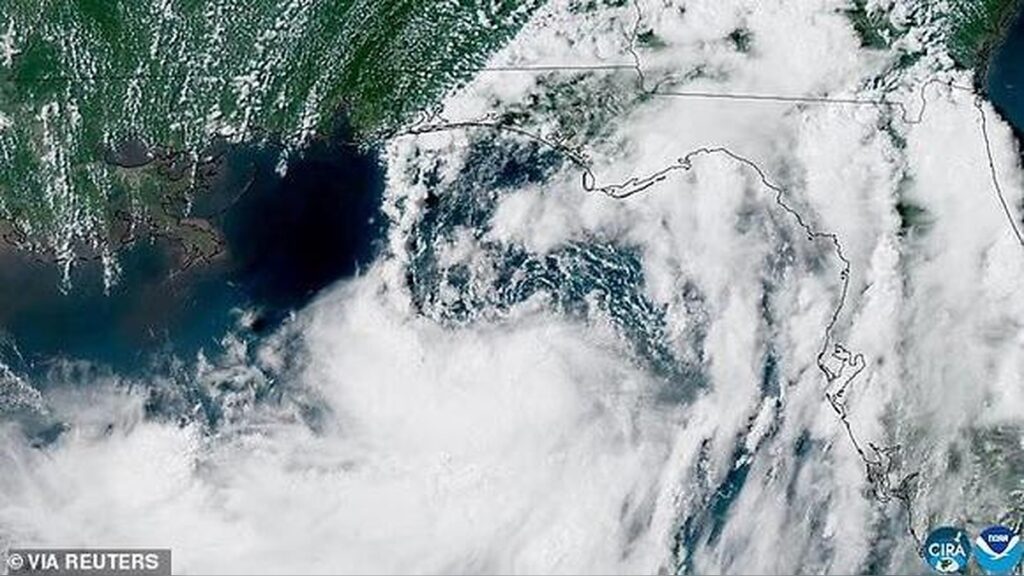
Millions of residents across the US Gulf Coast are being urged to prepare for dangerous weather as Tropical Storm Bertha gains strength and heads toward several southern states.
Meteorologists say the system is expected to bring heavy rain, damaging winds, storm surge, and hazardous coastal conditions, with Louisiana, Mississippi, Alabama, Texas, and parts of Florida all under close watch.
Bertha became the second named storm of the Atlantic hurricane season after forming off Florida’s coast on Monday evening.
Since then, the storm has continued to organize over the Gulf, prompting growing concern among forecasters about its potential impact later this week.
New Orleans Among Areas Facing Possible Direct Strike
Weather models indicate that Bertha could make landfall as early as Wednesday night, with southeastern Louisiana emerging as one of the most likely impact zones.
Current projections suggest the storm could move close to eastern Orleans Parish, placing neighborhoods including New Orleans East, the Lower Ninth Ward, and communities near Lake Pontchartrain and the eastern Mississippi River at heightened risk.
However, meteorologists caution that the exact path remains uncertain.
Small shifts in the storm’s trajectory over the coming days could significantly alter where the strongest winds and heaviest rainfall occur.
Warnings Issued Across Several Gulf States
Authorities have already issued tropical storm warnings for coastal sections of Louisiana, Mississippi, and Alabama as Bertha continues to strengthen.
Forecasters expect widespread rainfall totals of up to eight inches across portions of the Gulf Coast, accompanied by sustained winds ranging between 40 and 60 mph.
Communities stretching from the Florida Panhandle to major metropolitan areas such as Mobile, New Orleans, and Houston are expected to experience severe weather conditions if current forecasts hold.
Storm Surge and Coastal Flooding Raise Serious Concerns
Meteorologists are warning that storm surge could become one of Bertha’s most dangerous hazards.




Forecasts suggest water levels along parts of the Gulf Coast could rise by as much as three feet across more than 400 miles of shoreline extending from Florida to western Louisiana.
The National Hurricane Center has also issued a Storm Surge Watch, warning that rising seawater moving inland could create life-threatening flooding in vulnerable coastal communities over the next two days.
Officials are advising residents living in low-lying coastal areas and boat owners to take precautions, as strengthening winds and rough seas could damage vessels, overwhelm marinas, and create dangerous conditions on the water.
Forecast Depends on Bertha’s Path Over Warm Gulf Waters
Weather experts say Bertha’s future intensity will largely depend on how long its center remains over the warm waters of the Gulf.
AccuWeather Lead Hurricane Expert Alex DaSilva explained that if the storm closely follows the coastline, stronger winds may be limited, but prolonged heavy rainfall could significantly increase flooding risks across the central Gulf Coast before spreading farther inland.
Another possible scenario would see Bertha drift farther south over open water.
In that case, the storm would have additional time to strengthen before approaching land, potentially reaching the upper range of tropical storm intensity or even becoming a hurricane before making landfall.
Wind Shear Could Influence the Storm’s Strength
Meteorologists are also monitoring strong upper-level wind shear moving southward from the northern United States.
Those winds are currently disrupting Bertha’s thunderstorms, preventing rapid organization near the coast.
While the wind shear could weaken portions of the storm, experts note it may also steer Bertha farther into the Gulf, allowing it to remain over warm ocean waters for a longer period.
That scenario could fuel additional strengthening before the system turns back toward the coastline.
Texas Communities Remain on Alert
Should Bertha shift farther west, forecasters say the Texas coastline could become increasingly vulnerable.
Areas including the Texas Hill Country remain especially susceptible to flooding because of saturated ground and infrastructure that has yet to fully recover from recent catastrophic floods.
Meteorologists warn that additional heavy rainfall falling on already waterlogged terrain could quickly overwhelm rivers, drainage systems, and roads, increasing the risk of dangerous flash flooding.
Flash Flooding Identified as the Greatest Threat
The National Weather Service has emphasized that flash flooding is expected to pose one of the greatest dangers wherever Bertha makes landfall.
Flash floods can develop within minutes or hours of intense rainfall, particularly in urban areas, low-lying neighborhoods, and near streams where water levels rise rapidly.
Because they often occur with little warning, emergency officials continue to urge residents in threatened areas to closely monitor forecasts and heed evacuation or safety instructions if conditions worsen.
