
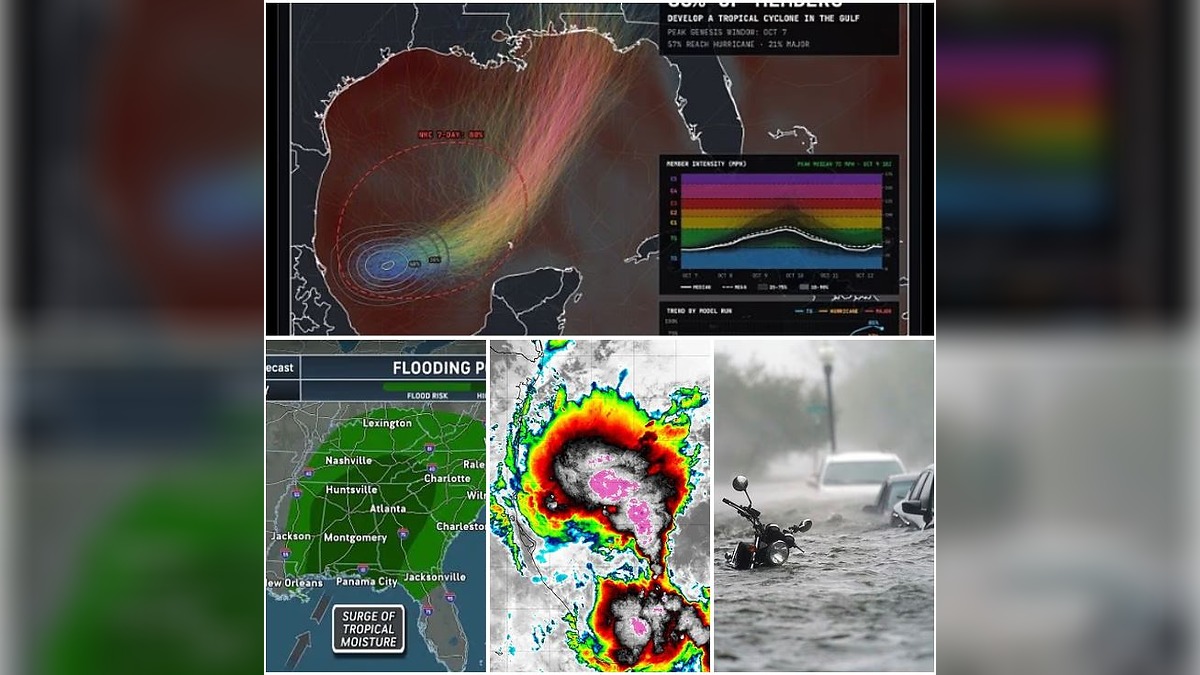
A developing tropical system in the Gulf of America is being closely monitored as forecasters warn that it could strengthen into a hurricane before reaching the US Gulf Coast later this week.
The National Hurricane Center has placed the system, currently designated Invest 92L, under close observation and gives it a 90% chance of becoming a tropical cyclone within the next 48 hours. If it develops into a named tropical storm, it would be called Isaias.
The system is currently located in the southwestern Gulf near the Bay of Campeche, where increasingly organised showers and thunderstorms are developing.
Landfall Could Come This Weekend
Forecast models indicate that the system could move north or northeast towards the United States later this week.
While the precise path remains uncertain, current projections favour a potential landfall somewhere along the central Gulf Coast, with areas from southeastern Louisiana towards the Florida Panhandle among those being monitored.
The uncertainty is partly due to the fact that the system has yet to develop a well-defined centre. Its eventual track and strength will become clearer as it becomes more organised.
Hurricane Strength Remains Possible
Forecasters are watching closely to determine how much the system can intensify over the warm Gulf waters.
AccuWeather has raised the possibility that the system could become a hurricane, although atmospheric conditions could still limit its development. Wind shear associated with the jet stream may disrupt the storm as it moves northward.
Other forecast models have also suggested the possibility of hurricane-strength winds, although there remains considerable uncertainty over the system’s eventual intensity.
A Category 1 hurricane would have sustained winds of at least 74 mph, while a Category 3 hurricane would require sustained winds of at least 111 mph. At this stage, however, forecasters are not treating a major hurricane as the most likely outcome.




Heavy Rain May Be the Biggest Threat
Regardless of whether the system reaches hurricane strength, widespread rainfall is expected to be one of its most significant threats.
The Southeast has already experienced substantial rainfall in recent days, and additional tropical moisture could worsen flooding across parts of the Gulf Coast and inland Southeast. AccuWeather warns that heavy rain could lead to flooding along rivers, streams and bayous, with some locations potentially experiencing significant flooding.
The threat is not limited to coastal communities because tropical rainfall can extend well inland from the eventual landfall point.
Multiple States Could Be Affected
The potential storm could bring heavy rain and strong winds to several states, depending on its eventual track.
Louisiana, Mississippi, Alabama and the Florida Panhandle are among the areas currently facing the greatest potential for direct impacts. Forecast uncertainty means other parts of the Southeast could also experience significant rainfall.
Weather threats could extend farther inland, with parts of Georgia, Tennessee and the Carolinas also potentially receiving heavy rain.
Wind Shear Could Determine Storm’s Fate
One of the key factors determining whether the system becomes a hurricane will be its ability to overcome strong upper-level winds.
Wind shear can disrupt the organisation of tropical systems and prevent them from strengthening. AccuWeather meteorologist Alex DaSilva said forecasters expect the developing area of thunderstorms to overcome some of that shear and potentially evolve into a tropical depression or tropical storm.
However, stronger shear later in the system’s development could still weaken or distort it before landfall.
Atlantic Season Has Yet to Produce a Hurricane
The potential Gulf storm comes during an unusually quiet Atlantic hurricane season.
As of October 6, the National Hurricane Center reported that there were no tropical cyclones in the Atlantic basin.
The developing Gulf system could therefore become the Atlantic season’s next named storm and potentially its first hurricane, although its eventual strength remains uncertain.
Gulf Coast Residents Urged to Monitor Forecasts
With the system still developing, forecasters are cautioning residents not to focus solely on whether it officially becomes a hurricane.
Heavy rainfall alone could create dangerous flooding, particularly in areas that have already received significant precipitation.
Residents across the Gulf Coast and Southeast are being urged to monitor updated forecasts as meteorologists gather more data and refine the expected track and intensity of the system. A hurricane-hunter mission is also planned to collect additional information on the disturbance.
For now, the developing system remains a closely watched threat, with the coming days expected to determine whether it becomes Tropical Storm Isaias and how serious the impacts could be along the US coast.

