
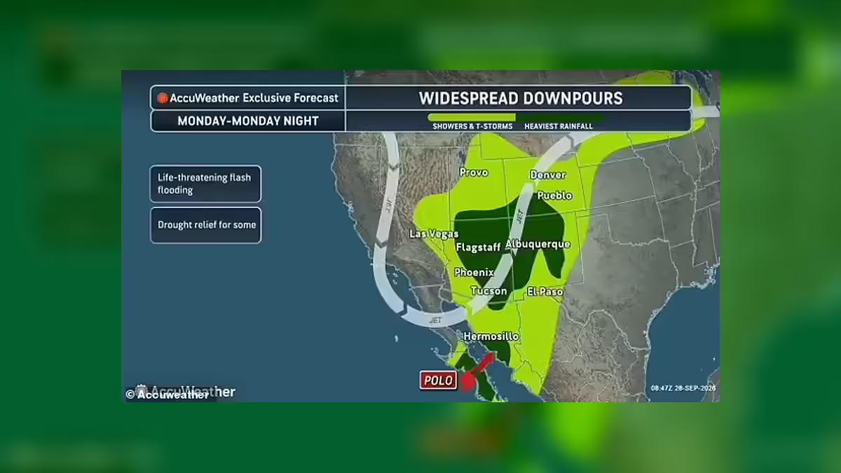
Hurricane Polo is moving toward the Baja California Peninsula with dangerous weather expected in Mexico before its moisture spreads into the United States, where forecasters are warning of a prolonged flood threat across parts of the Southwest and central US.
The storm remained a powerful Category 3 hurricane in the latest National Hurricane Center advisory, with maximum sustained winds of 125mph. The system is forecast to weaken as it moves inland, but its tropical moisture is expected to fuel heavy rainfall well beyond Mexico.
Baja California faces the first major impact
Polo is expected to reach the Baja California Peninsula as residents prepare for potentially destructive winds, heavy rain and flooding.
The National Hurricane Center has issued hurricane warnings for portions of Baja California Sur and mainland Mexico as the storm moves northward. The latest forecast showed Polo maintaining hurricane strength as it approaches the peninsula before weakening rapidly after moving inland.
Officials have warned that heavy rainfall could trigger life-threatening flooding and mudslides, particularly across steep and mountainous terrain.
Tropical moisture will push into the United States
Although Polo is not expected to remain a hurricane by the time it reaches the United States, its remnants could have a significant impact.
Moisture associated with the storm is expected to move northward into the Southwest, combining with another weather system over the western US. That interaction could produce several days of heavy rain and thunderstorms across a broad area.
The National Weather Service has already issued flood watches for areas of New Mexico and Texas, with additional flood concerns extending across the wider Southwest.
New Mexico and Texas face significant flood risk
Communities across New Mexico and western Texas are among those facing heightened concerns as tropical moisture reaches the region.
The National Weather Service says flash flooding could affect rivers, streams, low-lying areas and locations with poor drainage. In parts of southeast New Mexico and southwest Texas, saturated ground could make flooding more likely.




The threat is expected to continue through Tuesday night in some areas.
Rainfall could provide relief from drought
The incoming moisture is not entirely bad news for the drought-stricken Southwest.
Forecasters say substantial rainfall could provide some much-needed relief to areas that have experienced exceptionally dry conditions. However, the speed and intensity of the rainfall could also overwhelm the ground and drainage systems, creating a difficult balance between beneficial precipitation and dangerous flooding.
AccuWeather has warned that some areas could receive several inches of rain, with locally much higher totals possible in parts of Texas and New Mexico.
Polo was briefly an exceptionally powerful hurricane
Polo has already undergone significant changes during its journey across the eastern Pacific.
At one stage, the hurricane became extraordinarily intense, with reported estimates placing its winds near levels that prompted discussion about hypothetical Category 6 hurricane thresholds.
However, the National Hurricane Center’s official classifications have remained within the existing five-category Saffir-Simpson scale, with Polo most recently classified as Category 3.
The storm could affect a much wider area
Polo’s influence is expected to extend far beyond the immediate Southwest.
As tropical moisture is drawn northward, rainfall and thunderstorms could spread into portions of the Rockies, Southern Plains, Midwest and eventually farther east.
The interaction between Polo’s remnants and another weather system could create a broad zone of unsettled weather lasting several days.
Residents urged to take flood warnings seriously
The greatest concern for communities in the storm’s path is no longer simply whether Polo remains a hurricane.
Even after weakening, the system can transport large amounts of tropical moisture into areas that may be vulnerable to rapid flooding.
Residents in areas covered by flood watches are being urged to monitor local National Weather Service updates and be prepared to move to higher ground if flooding develops.
Polo’s latest forecast illustrates how a major Pacific hurricane can continue to pose significant hazards hundreds of miles from where it first makes landfall.

