Residents along Florida, Georgia, and the Carolinas are preparing for potentially dangerous flooding as Tropical Storm Imelda intensifies over the next 24 hours.
Meteorologists have issued warnings about heavy rain, flash flooding, and treacherous coastal conditions as the storm slowly moves toward the East Coast.
Although Imelda’s path is shifting, forecasters caution that the storm still poses a significant threat to life and property.
The Rare Fujiwhara Effect Could Redirect the Storm
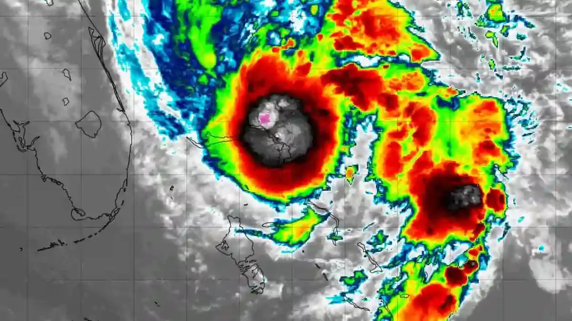
Experts say the East Coast may be spared from the worst of Imelda thanks to a rare weather phenomenon known as the Fujiwhara Effect.
This occurs when two tropical cyclones—such as hurricanes or tropical storms—come within about 900 miles of each other, causing their paths to interact.
Currently, Category 4 Hurricane Humberto, located near the Bahamas, is expected to influence Imelda’s trajectory, pulling it away from the U.S. mainland.
In some cases, a stronger hurricane like Humberto can even absorb a weaker storm, creating an even larger system.
Flash Flooding Remains a Major Concern
Even with Imelda being steered east, forecasters warn that heavy rainfall could still cause flooding in coastal and inland communities.
Up to four inches of rain is expected across parts of Florida, eastern Georgia, and the Carolinas through Tuesday.
Storm surges, thunderstorms, and life-threatening rip currents could impact areas from southern Florida all the way up to Atlantic City, New Jersey.
Rip currents, which can drag swimmers away from shore, remain particularly dangerous along affected beaches.
Imelda’s Turn Could Provide Drought Relief
As the storm curves eastward toward Hurricane Humberto, some meteorologists note a silver lining.
AccuWeather senior meteorologist Chad Merrill explained that the rainfall from Imelda may help relieve drought conditions that have affected parts of the Southeast over the summer.
Despite the threat of flooding, this unexpected rainfall could bring much-needed water to parched areas in the Carolinas.
Historical Context: Rare Storm Interaction
This interaction between Imelda and Humberto marks the first time since 2016 that two hurricanes have displayed this type of rotational pattern.
That year, Hurricanes Matthew and Nicole similarly interacted in the Atlantic, creating complex and unpredictable storm paths.
Experts say the Fujiwhara Effect is unusual and can dramatically alter forecasts, making it critical for residents to stay updated as the situation develops.
Imelda Set to Grow into a Hurricane
Tropical Storm Imelda is expected to strengthen into a Category 1 hurricane by Tuesday.
Models predict that instead of making landfall along the U.S. coast, Imelda will follow Humberto into the Atlantic, targeting the Bahamas by Thursday.
This shift could prevent a catastrophic direct hit on Florida, Georgia, and the Carolinas, though minor to moderate damage remains a possibility in low-lying areas.
2025 Hurricane Season Reaches Peak Intensity
The U.S. is currently in the height of the Atlantic hurricane season, which runs through November 30.
This year has been notable for back-to-back Category 5 storms, a rare event not seen in over nine decades.
Hurricane Humberto reached 160 mph winds before weakening slightly to Category 4, while Imelda is the ninth named storm of the season.
Overall, the season has been quieter than predicted, with fewer tropical storms and hurricanes than NOAA projected earlier this year.
Communities Urged to Stay Alert
Emergency officials continue to urge residents along the Southeast coast to monitor forecasts closely and prepare for flooding, dangerous surf, and heavy rainfall.
Local authorities recommend checking evacuation routes, securing property, and staying updated via trusted weather sources.
Potential Impacts on the East Coast
Even though the Fujiwhara Effect may save the East Coast from a direct hurricane hit, dangerous rip currents, storm surges, and thunderstorms are still expected.
Residents should exercise caution at beaches and coastal areas, as the combination of rainfall and rough surf could create hazardous conditions.
Looking Ahead: Imelda and Hurricane Humberto
As Tropical Storm Imelda interacts with Hurricane Humberto, forecasters stress that predictions remain fluid.
Storm watchers are keeping a close eye on both systems to anticipate any changes in trajectory, intensity, or potential impact on the U.S. and Caribbean islands.